s the Wisconsin Glaciation receded, it broke
up into smaller glacial ice sheets, which in turn broke up into smaller ice
sheets, and eventually into individual glaciers. At the right are the Cordilleran
and Laurentide ice sheets produced by the melting of the Wisconsin Ice Sheet,-
as they were 13,000 years ago.
Here we see how the land of the MacKenzie Water
Basin emerged first, providing an early path for the Clovis people to follow
as they began to populate the Americas.
It is along the southern regions of this path
that the Clovis Kill Sites are most concetrated. Oddly enough, Clovis
points are not found along the northern portion of this route. In fact the
Clovis point I found, is the most northern find of any Clovis point., at 57°
7' N. Latitude.


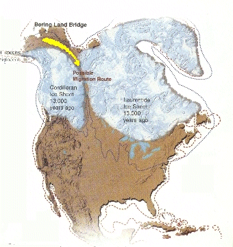 As the Wisconsin Glaciation receded, it broke
up into smaller glacial ice sheets, which in turn broke up into smaller ice
sheets, and eventually into individual glaciers. At the right are the Cordilleran
and Laurentide ice sheets produced by the melting of the Wisconsin Ice Sheet,-
as they were 13,000 years ago.
As the Wisconsin Glaciation receded, it broke
up into smaller glacial ice sheets, which in turn broke up into smaller ice
sheets, and eventually into individual glaciers. At the right are the Cordilleran
and Laurentide ice sheets produced by the melting of the Wisconsin Ice Sheet,-
as they were 13,000 years ago.